NOAH-JJCA Project. Multinational Caspian Sea-Aral Sea-Dead Sea Project. Persian Gulf
 Water and Energy: Alternative Solution to the Conflict in the Western Asia-Middle East
The Project Noah was conceptualized, planned and prepared with the goal of transferring about 70% (3000 m³/s) of the Pechora River’s discharge to the Arctic Ocean, which would bring great benefits to cities and towns of Komi, Komi-Permiak, Perm, Udmurtia, Tatarstan, Ulyanovsk, Samara, Saratov, Volgograd, Astrakhan, and to the hydroelectric plants of the Volga-Kama system.

This means that once the water transfers start contributing to strengthening the development in the various regions of Russia, and after traveling 3,250 km from the Pechora River to the Caspian Sea, the largest lake on the planet will have an extra 3000 m³/s of water.
When combining the above transfer with the flow of the Volga, Ural, and other rivers, there will be an additional contribution of about 1000 m³/s to the Aral Sea. This will help restore its natural beauty and facilitate further water transfers to Western Asia and the Middle East (2000 m³/s).
Thus, the major works in Project Noah to be located in the eastern part of European Russia would be as follows (north to south):
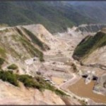
a) Mario E Dam (North Latitude: 65 ° 25 ‘ and East Longitude: 52 ° 15’). To be built downstream from the confluence of the Pechora and Izhm rivers, it would be the key project to control and derive 70% of the Pechora River basin runoff
b) 111-km Monica Pumping System, consisting of two pumping stations and two storing facilities interconnecting the Mario E Dam with the Vym River (part of the Dvina River basin).
c) Victor M Dam (North Latitude: 62 ° 19 ‘and East Longitude: 50 ° 43’). Located on the Vym River right before its confluence with the Vychegda River aimed at regulating the in-transit flow and transfer to the Roman M Dam
d) 21-km Vychegda-Vym System, located on a natural transfer channel within the Dvina River basin, to be used to drive water from the Pechora River. Formed by a storage facility and a pumping plant
e) Roman M Dam (North Latitude: 61 ° 52 ‘ and East Longitude: 52 ° 01’). Located on the Vychegda River right before its confluence with the Lokehim River aimed at regulating and transferring flows to the Volga River basin.
f) 115-km Roman M Dam-Veslyana River System (natural incline, traveling 65 km) aimed at transferring in-transit water to the basin of the Volga and Kama Rivers. Formed by two pumping stations and two diversion storing facilities
g) Confluence with the Veslyana River (North Latitude: 60 ° 59 ‘and East Longitude: 52 ° 58’). From this point on, all discharges originating at the Pechora River would take advantage of existing facilities along the Volga-Kama System
h) Volga-Kama Hydroelectric System. The 3000 m³/s to be added to the Kama and Volga rivers would increase electricity production by 35% and help retain consistent levels
i) Aral Sea-Caspian Sea System. Traveling 450 km to derive 1000 m³/s. Formed by three powerful pumping stations and three large storing facilities supplying the Aral Sea with invigorating fresh water and restore its former lake surface of 66,500 km².

Project Noah would take advantage of physiographic conditions and facilities to interconnect the basins of the Dvina, Pechora, Kama and Volga rivers by the means of highly-competitive, well-conceptualized and planned hydro-energetic infrastructure. It implies that water would travel 4000 km starting at the Mario E Dam all the way to the Aral Sea.
About 17% (or 680 km) of the projects would be of new construction, including dams, channels, penstock, etc. The other 3320 km are actual natural conduits, dams and reservoirs of the Volga-Kama system. Overproduction of the hydroelectric plants would supply electricity to the project’s pumping systems.
According to the above, all several works, that since the days of the extinct USSR, utilize the valuable resources of the Amu Dar’ya river basin, which is shared by Tajikistan, Afghanistan, Turkmenistan and Uzbekistan, and the discharge from the Syr Dar’ya river basin mainly used by Kyrgyzstan and Kazakhstan for irrigation, power generation, water supply, navigation, tourism, and so on, are the fundamental cause for the decline and virtual disappearance of the Aral Sea.
Project Noah by restoring a high-percentage of volumes to both rivers, would help at starting the full revival of the Aral Sea and establishing a new era of engagement and development in several Central Asian countries and the Russian Federation.
So based on modern basic infrastructure such as dams, reservoirs, channels, etc., along with powerful equipment and electromechanical facilities, would bring back modern and fruitful regional relationships sustained on collaboration, progress and useful, constructive employment. All fundamental principles to overcome disagreements and historical conflicts. Caspian Sea-Dead Sea Project (JJCA) which would create renewed expectations of peace and prosperity in Western Asia.
Proiect Noah. Caspian Sea-Dead Sea Project (JJCA):
With the goal of diversifying the participation of the already operational and vast basic infrastructure in your country, it is important to reinvigorate and expand existing developments throughout the Russian Federation. Such perspective along with well-defined plans and works to enable water transfers from the rivers of the north to the seas of the south would translate in higher levels of electricity generation, larger areas for irrigation, abundant water supply, and so on.
We consider that the unequal and dangerous conflict in the Western Asia-Middle East is caused by the control and use of the hydraulic and power resources.
The Mesopotamia region, with its high zone located in Syria; and its middle and low zones (that represent the greater area and account for abundant volumes of surface and underground water) located in Iraq; represent the most coveted river basin in this highly conflicted region of the world.

1 It implies that without hydrocarbons a country survives and can be developed. Without water a country cannot live. Petroleum is exported, water cannot be imported, and that’s the reason why each country must depend on its own resources. If Iraq has both natural resources and the other countries have deficiencies, insecurity and resentment are generated as a result. Coexistence and prosperity would exist only with the creation of a well-conceptualized multinational project.
2 In special circumstances and in an to-be-agreed upon basis of interests, mutual commitments and benefits are recommended to implement water transfer between nations – only in case these nations obtain consensus and agree that it is feasible to create an important and well -planned project of infrastructure.
In case of an agreement, the infrastructure project would be located off of the Caspian Sea, which has a total surface area of 371,000 square kilometers, and is fed by the Volga and Ural Rivers, among others (flow rate approx. 9000 m³/s).
This international region counts with the largest hydrocarbon deposits of the planet (735,000 million petroleum barrels, including reserves in the Caspian Sea).
3 The Caspian Sea is one of the most important natural lakes in the world. It is located 28 meters below sea level. It’s characterized by a soft slope in the North – Russia – and by its maximum storage capacity and depth (1,000+ meters) in the South – Iran -. If the Northern part decreases by a few meters, the water moves away several kilometers due to its almost-horizontal sea bottom. Although in the South – where the hydro-energetic transfer facilities are to be located – there are ideal technical advantages and conditions to take advantage of.
4 Therefore, the water conduction would solve the serious problems of water shortages that originate in the Southern part of the immense Caspian Sea/Lake (eight centimeters of its storage capacity are equivalent to 30 billion cubic meters, enough to irrigate three million hectares a year and to turn extensive desert lands into fertile land) in order to transfer abundant volumes of water to the Urmia Lake, located West of the Caspian Sea, also in Iranian territory.
5 As a result of this natural dam, the water flow would be pumped back through tunnels, channels… on the order of 2000 m³/s (22% of their runoffs) into the Northern zone of Iraq (Kurdish region) to jettison into the Tigris River, located North of Mosul. Continuing through these waterways and channels, the Tigris River would be united with the Khabar River, which is a tributary of the Euphrates. In these rivers that form a natural boundary of the Mesopotamia region, enough water would remain to irrigate lands in the North of Syria and Iraq as well as to distribute it to several other populations. Also and in the case of being feasible, additional Euphrates’ drainage would be channeled to the Northeast of Saudi Arabia.
6 The Caspian Sea-Dead Sea transfer would continue in the Southern zone of Syria, where supply to population centers and new irrigation districts would take place, as well as possible diversion channels to provide water to the Northeast of Jordan. This conduction of life and progress would participate in solving ancestral ethnic and religious differences. The water supply would arrive North of Israel, which would spill out fresh water to the Sea of Galilee. The additional volume in this unstable zone would equip bordering cities of Syria, Israel, and Jordan and eliminate conflicts of water usage and by finding alternative political agreements.
7 Off of the Sea of Galilee, part of the water transfers would continue to the South by the Jordan River in order to increase irrigation land and to equip several coastal populations located in the Western Margin territory – Palestine, Jordan and Israel.
This would unload the last and valuable transferred volumes of water to the Dead Sea, so that these two inland seas located below sea level (the Galilee Sea, 200 meters and the Dead Sea, 400 meters) would undergo simultaneous cleaning, rehabilitation, and conservation processes magnifying their historical legacy and presence.
8 This means that this strategic and fundamental 1,500-kilometer long water conduct with a general East-West course with a declining direction towards the Southwest would be formed by treatment and pumping plants, (it’s required to know if the low salinity of the Caspian Sea allows the usage of the derived water for agricultural and urban uses) tunnels, pipelines of great diameter, natural riverbeds, dams, water channels, irrigation structures, as well as by updating existing hydraulic facilities in operation.
Besides supplying water to thirsty populations and extensive land to increase the food production remarkably in Iraq, Syria, Jordan, Lebanon, Palestine, and Israel, it would facilitate the conciliation of interests and controversies in a region with constant confrontation to control hegemony and resources.
9 Among complementary facilities that assure and even increase the Caspian Sea’s extension and capacity, the water diversion of the Donets and Don Rivers stands out; this water diversion would allow both rivers to flow into the Caspian Sea, rather than into the Sea of Azov. Both rivers, Donets and Don, already have connecting and water transfer-enabling facilities.
It is also convenient to channel the aforementioned draining to the Volga River in order to increase its contributions to the Caspian Sea. In addition, and in the future, if social and politic situations facilitate it, The Dnieper River, which flows into the Black Sea, would be united with the Donets, Don, Volga and Caspian Sea.
10 In that way, the main rivers of Ukraine and European Russia would interlace by navigational channels and flow into the Caspian Sea. Otherwise, the Dnieper, Donets, and Don Rivers would flow their important water volumes into the Azov, Black, and Mediterranean Seas as currently happens.
The significant Caspian Sea-Western Asia project is to include other large-scale infrastructure projects in order to optimize the usage of natural resources and to connect different cities and populations. Of course, it’s mandatory to expand regional agreements of cooperation.
Therefore, when using petroleum, not like a war plunder, prize or tribute but rather as an essential support and complement to finance, build, and stimulate a large-proportion and far-reaching development through a great infrastructure project, the increasing and recurrent wars to control the water in such a representative region of human civilization could be solved.
The proposed infrastructure project would avoid that jealousies and arguments that now materialize in destruction and desolation to obtain control and administration of the region, would evolve towards renewed multinational objectives of cooperation, coordination, and accomplishments, where the common interest and commitment would be to guarantee the coexistence and progress in a peaceful way.
Multinational Project Noah-Jehovah-Jesus Christ-Allah (JJCA)
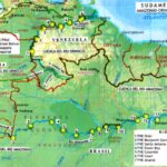
Countries: Russia, Kazakhstan, Uzbekistan, Iran, Iraq, Syria, Saudi Arabia, Jordan, Lebanon, Palestine and Israel.
Water and Power for southwest Asia and the Middle East. River basins included: Pechora, Dvina, Volga, Caspian Sea, Aral Sea, Lake Urmia, Tigris, Euphrates, Leontes, Jordan (Sea of Galilee and the Dead Sea).
JJCA Project: Middle East Basic Flow Penstock and Channels to Transfer and Distribute 2000 m3/s
| Flow | North Latitude | East Longitude | Percentage of Flow |
| Caspian Sea-Lake Urmia 1 | |||
| Intake and Pumping Plant 1 | 38° 17.805’ | 48° 46.061’ | 100 |
| Pumping Plant 2 | 38° 17.379’ | 48° 42.530’ | 100 |
| Pumping Plant 3 | 38° 17.557’ | 48° 40.825’ | 100 |
| Control Reservoir | 37° 58.261’ | 47° 51.682’ | 95 |
| Lake Urmia. Discharge | 37° 58.993’ | 45° 17.034’ | 90 |
| Lake Urmia-Grand Zab River 2 | |||
| Intake and Pumping Plant | 37° 28.942’ | 45° 18.050’ | 85 |
| Grand Zab River. Discharge | 37° 18.112’ | 44° 40.007’ | 85 |
| Grand Zab River. Presse Dam3 | 36° 54.034’ | 43° 02.201’ | 85 |
| Presse Dam-Duhok River | |||
| Intake and Pumping Plant | 36° 53.902’ | 43° 0.507’ | 75 |
| Control Reservoir | 36° 52.754’ | 43° 53.718’ | 75 |
| Duockh River. Discharge | 36° 47.464’ | 43° 08.639’ | 75 |
| Tigris River. Saddam Dam 4 | 36° 57.843’ | 42° 49.471’ | 75 |
| Saddam Dam-Khabar River | |||
| Intake.and Pumping Plant | 36° 49.848’ | 42° 28.869’ | 65 |
| Control Reservoir | 36° 49.516’ | 42° 15.948’ | 65 |
| Khabar River. Discharge | 36° 47.852’ | 41° 08.916’ | 65 |
| Khabar River. al-Asad Dam 5 | 36° 15.697’ | 40° 47.721’ | 65 |
| al-Asad Dam- Tabqa Dam | |||
| Intake and Pumping Plant | 36° 17.716’ | 40° 45.286’ | 50 |
| Control Reservoir | 36° 15.135’ | 40° 25.668’ | 50 |
| Tabqa Dam. Discharge | 35° 55.273’ | 38° 27.016’ | 50 |
| Euphrates River. Tabqa Dam 6 | 35° 52.133’ | 38° 33.661’ | 50 |
| Tabqa Dam-Leontes River | |||
| Intake and Pumping Plant | 35° 49.084’ | 38° 26.762’ | 30 |
| Reservoir 1 and Pumping Plant | 35° 10.021’ | 37° 58.328’ | 30 |
| Reservoir 2 and Pumping Plant | 34° 55.381’ | 37° 49.639’ | 30 |
| Control Reservoir 3 | 34° 03.756’ | 36° 12.876’ | 30 |
| Leontes River.Discharge | 33° 36.929’ | 35° 43.086’ | 30 |
| Euphrates River. Tabqa Dam 7 | 33° 32.911’ | 35° 41.326’ | 30 |
| Qaraaoun Dam-Jordan River | |||
| Intake and Pumping Plant | 33° 32.902’ | 35° 41.696’ | 20 |
| Jordan River. Output Tunnel | 33° 29.478’ | 35° 46.819’ | 20 |
| Sea of Galilee 8 | 32° 49.443’ | 35° 35.425’ | 15 |
| Sea of Galilee-Jordan River Mouth | 32° 42.591’ | 35° 34.690’ | 15 |
| Dead Sea-Jordan River Mouth | 31° 45.631’ | 35° 33.494’ | 10 |
| Dead Sea 9 | 31° 30.970’ | 35° 28.739’ | 10 |
| Euphrates River-Sea of Galilee (Alternate) | |||
| Intake and Pumping Plant | 34° 54.298’ | 40° 34.362’ | 15 |
| Reservoir 1 and Pumping Plant | 34° 03.451’ | 39° 02.642’ | 15 |
| Control Reservoir 2 | 32° 59.048’ | 36° 39.388’ | 10 |
| Sea of Galilee. Discharge | 32° 49.462’ | 35° 38.098’ | 5 |
1 The Caspian Sea which is located at -28MSL and 371,900 square kilometers strong is considered to be the main storage location of the JJCA Project.
2 The Lake Urmia (1268AMSL) would maintaining its ideal conditions and facilitate transfers to the center of Middle East turning desert plains into productive orchards and providing water to populations.
3 The new Presse Dam on the Great Zab River (550AMSL) would transfer the respective water flow to the Tigris River.
4 The Saddam Dam on the Tigris River (315AMSL) would provide additional volumes to increase farmland, supply water to several towns in Iraq, and facilitate water transfers to the Khabar River.
5 The al-Asad Dam on Khabar River (285AMSL) would discharge into the Euphrates River to increase irrigation areas in Iraq, Syria, Jordan, and Saudi Arabia as well as transfer abundant flows of water to the Tabqa Dam.
6 The Tabqa Dam on the Euphrates River (300AMSL) would be most strategic location for the project. This location would supply water to populations and agricultural areas in the basins of the rivers Leontes and Jordan, as well as facilitating transfers to the Jordan River.
7 The Lac de Qaraaoun Dam on the Leontes River (858AMSL) by having more water, it would expand its role in the central part of Lebanon, it would also increase the allocation for district irrigation, populations and transfers to the Jordan River.
8 The Sea of Galilee located at -214MSL and being 166 square kilometers strong, would retain its ideal levels and storage areas. Also, it would increase water supplies to towns and irrigation areas.
9 The Dead Sea located at -415MSL and being 810 square kilometers strong, would be the final destination of the JJCA Project. Its revitalizing waters would restore its magnificence, levels, capabilities, functions and dissipate its eventual disappearance.
Undoubtedly, the transfers from the Pechora river (3000 m³/s) would provide significant and diverse benefits in the basins of the Caspian Sea, Aral Sea, Lake Urmia, Tigris-Euphrates, Leontes and Jordan rivers (Sea of Galilee and Dead Sea).
The JJCA project would comprehensively, commonly, and ultimately contribute to establishing a genuine peace in the Middle East.
Mexico City, Conceptualized February 2003, Updated June 2016.
To reflect that the disagreements and struggles in the Middle East have prevailed since ancient times, with alternating times of domination of old and recent civilizations to obtain supremacy, power, and wealth; requires today more than ever an opportunity and vote of confidence of the present civilizations and nations to find and to develop a common horizon of fairness and shared prosperity.

NOAH-JJCA Project. Multinational Pechora River-Dvina River-Volga River-Caspian Sea-Aral Sea-Dead Sea Project

JJCA Multinational Project. Flow Caspian Sea-Lake Urmia: 334 km

JJCA Multinational Project. Flow Lake Urmia-Grand Zab River

JJCA Multinational Project. Flow Presse Dam-Saddam Dam

JJCA Multinational Project. Flow Saddam Dam-Khabar River
JJCA Multinational Project. Flow al-Asad Dam-Tabqa Dam


JJCA Multinational Project. Flow Tabqa Dam-Qaraaoun Dam

JJCA Multinational Project. Flow Qaraaoun Dam-Jordan River

JJCA Multinational Project. Flow Qaraaoun Dam-Jordan River-Galilee Sea

JJCA Multinational Project. Holy Land. Flow Jordan River-Galilee Sea-Dead Sea

JJCA Multinational Project. Euphrates River-Sea of Galilee (Alternate)
The momentous Caspian Sea-Western Asia-Middle East Project would contribute to correct and conciliate divergent aspirations and goals. It would respect the sovereignty and the principles of international law. Iran, Iraq, Syria, Jordan, Saudi Arabia, Palestine, Lebanon and Israel, would create the basis of a new era of progress and agreements of peace, that would conciliate actions, wills and efforts to negotiate and distribute the hydraulic and power resources between the Hebrew, Christian and Muslim nations (JJCA).
J Jehovah
JC Jesus Christ
A Allah

JJCA Multinational Project. Flow Caspian Sea-Lake Urmia: Alternative A 334 km. Alternative B 460 km
Proyecto NOAH-JJCA. Medio Oriente. Mar Caspio-Mar Aral-Mar Muerto-Golfo Pérsico. NOAH-JJCA Multinational Project. Persian Gulf
Región Sureste. Países: Kuwait, Arabia Saudita-Este, Bahréin, Qatar y Emiratos Árabes Unidos.

Con la intención de diversificar y complementar los objetivos y las funciones del conveniente y extenso Proyecto Multinacional NOAH-JJCA (https://blog.friasgroup.com/2016/05/31/proyecto-noah-jjca-proyecto-mar-caspio-mar-aral-mar-muerto/), concepto de desarrollo que incluye varias naciones de Asia suroccidental, región caracterizada por ancestrales conflictos étnicos, religiosos, hegemónicos, con disimiles culturas, creencias y costumbres, resulta inaplazable determinar y ejecutar obras hidroenergéticas de amplia visión y largo alcance que sean una auténtica alternativa para solucionar a fondo y en definitiva la previsible escasez de agua, así como alejar el riesgo de una eventual conflagración que comprometería la posteridad y trascendencia de la humanidad.
De imaginar y evaluar este desfavorable panorama es imprescindible reflexionar que la mayoría de las naciones del Mundo Islámico e Israel -único país con religión Judía- se encuentran en crisis por la progresiva insuficiencia del vital líquido. Significa, casi todo Oriente Medio -excepto Turquía, Siria e Iraq que comparten las cuencas de los Ríos Mesopotámicos Éufrates y Tigris- tiene un futuro inseguro: Qatar, Líbano, Irán, Jordania, Kuwait, Arabia Saudita, Palestina, Emiratos Árabes Unidos, Bahréin, Omán, Yemen e Israel. Esta situación sería lo equivalente a los designios Bíblicos-Antiguo Testamento previos a las devastadoras inundaciones anunciadas a Noé (en el Corán Nuj) por Dios (Iahvé); sólo que en contraposición, pues ahora se refieren a severas sequías y climas ardientes… En el pasado fueron extensas inundaciones (exceso de agua). Hoy sequías (escasez de agua).
De modo que el porvenir de los habitantes en Oriente Medio -Mundos Árabe y Judío donde no existe ninguna Nación Cristiana- es delicado y desalentador. La ONU y otros organismos internacionales consideran a esta región árida y semi-árida con cero por ciento de reservas de agua. Esta situación torna urgente establecer alternativas de solución para evitar su previsible ruina. En contradicción, en particular en los países de la margen suroccidental del Golfo Pérsico y/o Golfo Arábigo, cuentan con las mayores reservas de hidrocarburos, estratégica riqueza natural que debe ser utilizada para respaldar y ejecutar acciones, planes, programas y grandes obras de infraestructura hidroenergéticas, a fin de asegurar la posteridad de estos países y no únicamente destinar los ingentes ingresos monetarios en la suntuosidad, armamentismo y en onerosa infraestructura inmobiliaria.
Frente a tan sui generis condiciones connaturales y, de acuerdo a la inestabilidad histórica-religiosa-étnica (confluencia del Judaísmo, Cristianismo e Islamismo) y al considerar que hace cien generaciones nació Jesucristo-Hijo de Dios en Belén -población ubicada a 7 km al sur de Jerusalén (Tierra Santa)- resulta congruente extender los propósitos, aportaciones y beneficios del Proyecto Multinacional NOAH-JJCA. Mar Caspio-Mar Muerto, que a partir del año 2003 fue hecho del conocimiento de los Gobiernos de Irán, Iraq, Siria, Jordania, Arabia Saudita, Palestina, Líbano e Israel y posteriormente de los Gobiernos de Rusia, Kazajstán y Uzbekistán, a fin de transferir 3500 m3/s de los Ríos Pechora-Dvina-Kama-Volga a los Mares Caspio, Aral, Galilea y Muero para dotar de abundantes volúmenes a esos países y convertir inmensos territorios desérticos en productivos vergeles.
Al reflexionar que tan ambicioso y provechoso proyecto internacional crearía las bases de renovados convenios y compromisos de paz en tan convulsa región y, que al sumar acciones, voluntades y esfuerzos permitiría negociar, distribuir y compartir los recursos hidráulicos y energéticos entre los Pueblos Hebreo, Cristiano e Islámico, resulta oportuno reconfigurar y redefinir sus estratégicos conceptos y metas, incorporando otras naciones árabes con insuficiencia de agua… En Oriente Medio se instalan y funcionan cada vez más planta para desmineralizar agua marina, sólo que el alto consumo energético y la creciente demanda las tornan inconvenientes y dispendiosas
Conforme a este horizonte hídrico, resulta necesario ampliar las obras que forman el Proyecto NOAH-JJCA para derivar 500 m3/s a las Naciones Petroleras del Golfo Pérsico: Kuwait, Arabia Saudita-Costa Este, Bahréin, Qatar y Emiratos Árabes Unidos (E.A.U.). Al disponer suficiente agua, estos países islámicos podrían acceder a mejores condiciones de vida y expectativas de progreso. Este objetivo requiere consensuar y coordinar acciones de los Gobiernos Monárquicos regionales, lo cual facilitará redefinir las políticas y programas de exportación de hidrocarburos para aplicar un alto porcentaje de los ingresos petroleros en resolver la peligrosa e inevitable falta de agua. De visualizarse así las obras e instalaciones integrantes del Acueducto Río Éufrates-Dubái (A.R.E.D.):
Proyecto Multinacional JJCA. Conducción entre el Río Khabar-Presa al Dughayra y el Río Eúfrates-Presa al Asad. Derivación de 500 m3/s a las Naciones Petroleras del Golfo Pérsico.
1. Los volúmenes procedentes del Sistema Mar Caspio y en tránsito por la Presa al-Asad sobre el Río Éufrates que se derivarían a los distritos agrícolas ubicados en las partes media y baja de esta cuenca pertenecientes a Siria e Iraq se incrementarían con 500 m3/s a fin de canalizarlos a las naciones árabes del Golfo Pérsico.
2. Si se considera que un litro por segundo suministra agua a 300 habitantes y la actual población de Kuwait, Bahréin, Qatar y E.A.U. es de 18 000 000 y de Arabia Saudita de 32 500 000 (se presuponen en la costa oriental 10 500 000 habitantes), el caudal necesario para abastecer de agua a 28.5 millones de habitantes sería de 95 m3/s (288 litros per cápita diarios). El complemento -405 m3/s- se emplearían para usos industriales, agropecuarios y urbanos; o bien, sería suficiente para irrigar 1 277 200 hectáreas para producir alimentos.
3. Con la finalidad de hacer asequible este panorama hidro-agrícola en los países árabes del Golfo Pérsico, los 500 m3/s adicionales en el Río Éufrates, recorrerían 1360 km hasta las instalaciones y equipos hidráulicos por construirse en la margen derecha de este importante río mesopotámico. La conducción de los caudales sería a través de un nuevo Canal de Derivación de 87 km hasta confluir con las instalaciones y equipos de bombeo del A.R.E.D. La longitud de este acueducto es 1393 km y su capacidad inicial y final de 500 m3/s y 70 m3/s.
4. Las obras básicas del A.R.E.D. que tendría un rumbo sur-sureste-oriente: Obra de Toma, Plantas de Bombeo y Tuberías a Presión, así como los primeros 75 km quedarían en territorio iraquí Los Grandes Estanques Uno y Dos de Control y Transferencia con sus respectivas Centrales de Bombeo estarían situados en la zona occidental de Kuwait El primero a la elevación 115 msnm y el segundo a la altitud 200 msnm. La distancia entre ambos estanques es de 59 km El acueducto continuaría al tercer Estanque de Control y Transferencia ubicado a 250 msnm en la parte noreste de Arabia Saudita La distancia entre los Estanques 2 y 3 es 140 km.
5. A partir del Estanque 3 y hasta el Estanque Terminal Dubái (60 msnm) los caudales fluirían 1119 km por gravedad. En el recorrido por el litoral sureste del Golfo Pérsico, este magno y fundamental acueducto abastecería de abundante y revitalizante agua a las diversas poblaciones, ciudades, nuevos centros industriales y agropecuarios de las naciones del Golfo Pérsico Justo en el límite fronterizo de Arabia Saudita y los E.A.U., el trayecto del A.R.E.D cambia de dirección hacia el noreste para proseguir paralelo a la costa de los E.A.U. hasta el Estanque Terminal Dubái, localizado en la colindancia oriental de la moderna ciudad de Dubái.
6. Implica, el caudal derivado desde la Presa al Asad, al ser conducido 1359 km por el Río Éufrates hasta el Canal de Transferencia e iniciar así el suministro de suficiente agua a los países árabes del Golfo Pérsico, permitiría revertir y resolver la previsible insuficiencia del vital líquido. Es importante precisar que conforme se abastezca a las distintas ciudades, centros agropecuarios e industriales regionales, las dimensiones de las grandes tuberías y los sistemas de distribución disminuirían. De requerirse volúmenes adicionales se podrían transferir caudales excedentes del Río Éufrates; pues la ubicación de las obras, instalaciones y equipos del A.R.E.D no crearían conflictos por la extracción de mayores volúmenes como por los usos de agua con Iraq.

Proyecto Multinacional NOAH-JJCA. Acueducto Río Éufrates-Dubái (A.R.E.D.).
País |
Obra e Instalación * |
Latitud Norte |
Longitud Este |
Altitud, msnm |
Distancia acumulada km. Rumbo |
Siria |
Presa al Asad |
35° 52.246’ |
38° 33.868’ |
302 |
0. Sureste |
Iraq |
Canal Derivación |
30° 58.818’ |
46° 18.667’ |
4 |
1359. Sureste |
Iraq |
A.R.E.D Inicio |
30° 39.569’ |
46° 59.844’ |
11 |
1446. Sur |
Kuwait |
Estanque 1 |
29° 58.209’ |
47° 10.379’ |
115 |
1521. Sur |
Kuwait |
Estanque 2 |
29° 26.578’ |
47° 6.581’ |
200 |
1580. Sureste |
Arabia Saudita |
Estanque 3 |
28° 13.475’ |
47° 29.513’ |
250 |
1720. Sureste |
Emiratos Árabes Unidos |
Estanque Dubái |
25° 11.466’ |
55° 28.894’ |
60 |
2839. Noreste |
* El caudal inicial del A.R.E.D. sería de 500 m3/s y disminuiría según la demanda de agua en cada País Árabe. En su trayecto -1393 km- tendría siete deflexiones y varios sistemas de distribución para usos urbanos y agrícolas.
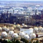
Sin duda, las características y conceptos técnicos, económicos, procesos constructivos, operación y conservación del A.R.E.D. representan grandes desafíos en tan excelsa región del Mundo Islámico. Ante la situación imperante, es oportuno enfatizar: Lo más dispendioso es aquello que es insuficiente, escaso o inexistente. Si en épocas pasadas la población regional era menor con los limitados recursos hidráulicos se cubrían los requerimientos de agua. El descubrimiento y aprovechamiento de los vastos y valiosos yacimientos petroleros, transformó el hábitat de los países del Golfo Pérsico; a grado tal, que hoy el destino y su dinámico desarrollo es incierto e impredecible.
Lo anterior reafirma: El dinero No es la riqueza de una nación… La auténtica riqueza son sus habitantes, que con su trabajo útil-constructivo y sus actividades creativas-productivas aprovechan los recursos naturales para beneficio de su país. Si en la actualidad funcionan diferentes redes de oleoductos, gasoductos y refinerías para exportar y transformar los hidrocarburos y obtener así cuantiosos dividendos, es factible afirmar que el dinero no es la esencia nacional. El Universo y todo su contenido son Energía y Agua… No es fortuna monetaria.
Desde luego para cubrir la demanda de agua a corto plazo, tal vez sea conveniente continuar con la construcción de Sistemas de Desalación de agua de mar; aunque por su onerosa operación -energética y económica- participen de manera limitada y decreciente. Es decir, la verdadera solución de amplia visión y largo alcance para garantizar una creciente prosperidad en el Mundo Islámico y Judío -Asia Suroccidental- lo ejemplifica el extenso y bien planificado Proyecto Multinacional NOAH-JJCA, lo cual exige la unidad y la colaboración de los quince países que lo integran.
Así, las Naciones Islámicas Qatar, Líbano, Irán, Jordania, Kuwait, Arabia Saudita, Emiratos Árabes Unidos, Siria, Iraq, Bahréin y Palestina además del único País Judío de HidroTerra: Israel, alejarían la prognosis de colapso por falta de agua. Este alentador horizonte, requiere subsanar animadversiones históricas-religiosas y la cooperación decidida con Rusia para trasvasar los caudales del Río Pechora a los Mares Caspio, Aral, Galilea, Muerto y a las naciones del Golfo Pérsico…

Proyecto Multinacional NOAH-JJCA. Países Productores de Petróleo de Medio Oriente-Región Sureste: Kuwait, Arabia Saudita-Este, Bahréin, Qatar y Emiratos Árabes Unidos que se beneficiarían con caudales trasvasados desde el Río Eúfrates (Cuenca Inferior. Canal de Conducción y Acueducto: 1480 km), a fin de evitar el previsible colapso por la insuficiencia de agua en tan rica región de hidrocarburos.
El Agua es la Vida. En Asia Suroeste-Oriente Medio (Mundos Islámico y Judío) su abundancia y/o escasez podría definir el futuro de la humanidad… Sin Petróleo se Puede Vivir… Sin Agua No se Puede Vivir.
Water is Life. In the Asia Southwest-Middle East (Islamic and Jewish Worlds) its abundance and/or scarcity could define the future of humanity…Without Petroleum You Can Live… Without Water You Can’t Live.
Manuel Frias-Alcaraz
Author of the Nationwide Project México Tercer Milenio
Mexico City, March 2003
© México Tercer Milenio. Documents, plans, programs, and all materials.


Acerca de este Artículo
Usted lee “NOAH-JJCA Project. Multinational Caspian Sea-Aral Sea-Dead Sea Project. Persian Gulf,” un artículo en México Tercer Milenio
- Publicado:
- 06.06.15 / 12pm
- Categoría:
- Proyectos
Sin comentarios
Comentarios | comments rss[?] | liga directa [?]